Often it is interesting to look back to see what previous planning schemes aimed to achieve, in times when planning was more overtly about city building, rather than 'effects management'.
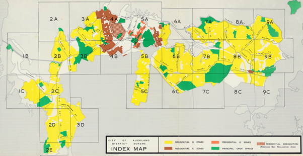
The map below is from the 1961 district scheme for (the old, pre amalgamation) Auckland City. The city hugged the coastal edge; inland where the boroughs like Newmarket, Mt Eden and Mt Roskill.

The plan was prepared under the 1953 Town and Country Planning Act. The general purpose of district schemes under that Act (section 18) was managing the development of the area to which the scheme relates (including, where necessary, the replanning and reconstruction of any area therein that has already been subdivided and built on) in such a way as will most effectively tend to promote and safeguard the health, safety and convenience, and the economic and general welfare of its inhabitants, and the amenities of every part of the area.
Maybe the proposed Natural and Built Environment Act could take a lead from this purpose statement: planning is about development and redevelopment, but in a way that promotes health, safety, convenience, welfare and amenities, not just more houses.
The map shows three residential zones – B (yellow), C (brown) and D (orange). Not too sure what happened to the Residential A zone. It looks like the western side of Ponsonby (along the line of John Street, St Marys Bay and Arch Hill were all in the Residential C zone, along with Parnell. The ‘D” zone was confined to the eastern edge of the Central Area.
Other zones included a Burnt Cray Products Zones (in Avondale) while the Freemans Bay ‘Reclamation’ area looks rather ominous.
The zone framework for B , C and D was pretty simple.
Dwelling houses, semi-detached houses and apartment houses where possible in all three zones. So plenty of housing choices. "Apartment house" meant any residential building which contains two or more household units and includes a block of flats. An apartment building did need a site with an area of 24 perches (about 600m2) in area.
Maximum height of buildings went from 30 feet (9m) in Residential B zone, to 50 feet (15m) in Residential C and 100ft (30m) in Residential D. A simple graduation of height away from the central area was foreseen. No need for density in the suburbs.
Building coverage in Residential B zone was 40%, but corner sites could go up to 50%, while rear sites where 30%. In the Residential C zone this coverage increased to 50%, 60% and 40% respectively.
Density for residential buildings was limited to 50 persons per acre in the Residential B zone. This rose to 100 persons per acre in Residential C zone and 200 persons per acre in the Residential D zone.
It is not clear from the scheme how residential density was measured at a site level. A rough guess is 50 persons per acre is equal to 6 or 7 dwellings per hectare in the B zone, and 13 to 14 dwellings per hectare in the C zone.
In a rough sort of way, the zoning pattern in the 1961 plan is what the National Policy Statement on Urban Capacity is trying to achieve – more density close to the city centre. So if the 1961 scheme had been implemented, with Ponsonby and Parnell sprouting 3 to 4 storey apartment buildings and Symonds Street with 8 storey apartments, would we have the housing crises of today?
Special Character was yet to be identified as a matter that should constrain redevelopment. The inner suburbs were yet to be gentrified, and if anything, there was concerns that Ponsonby may turn into a slum, so redevelopment was seen to be a good thing. Certainly Freemans Bay was seen as an area in need of redevelopment. Hence the special development area.
The NPS-UD doesn't think much of Special Character. How would Auckland look if the 1961 scheme had been followed through? Perhaps it is a good thing that there is always a gap between aspiration and reality in planning.
Retention of the inner suburbs has forced a focus on residential intensification in the central area, as well as in the suburbs outside the inner area. These are not bad outcomes. Could it be said to be a win-win-win? Character retained, a busier Central Area and more activity in the outer suburbs?