As the Auckland urban area’s population grows from 1.4 million to 2 million by 2043 under a medium growth scenario, the perennial issue is where is everyone going to live. How are we going to fit in another 600,000 people? If we think that the option of greenfields (outwards expansion) is no longer so easy (see this post), and most of the growth will be by way of redevelopment of the existing urbanised area, then how should we conceptualise the further development of the existing urban area of Auckland?
In this blog I want to explore the concept of neighbourhoods and what this may mean for the redevelopment and intensification of urban Auckland. The Auckland Plan made the big pitch for urban redevelopment over urban expansion, while the Auckland Unitary Plan has made room for the extra houses in a physical sense, based on its approach of intensification around centres. I don’t intend to traverse over that ground.
 What I want to do is look at a different way of conceptualising the city and its growth. Neighbourhoods play an important role in urban form and design and well functioning neighbourhoods deliver a whole host of social and economic benefits, but they are also a problematical concept as they can be used to create metaphorical walls around communities and be used to counter integration and mixing.
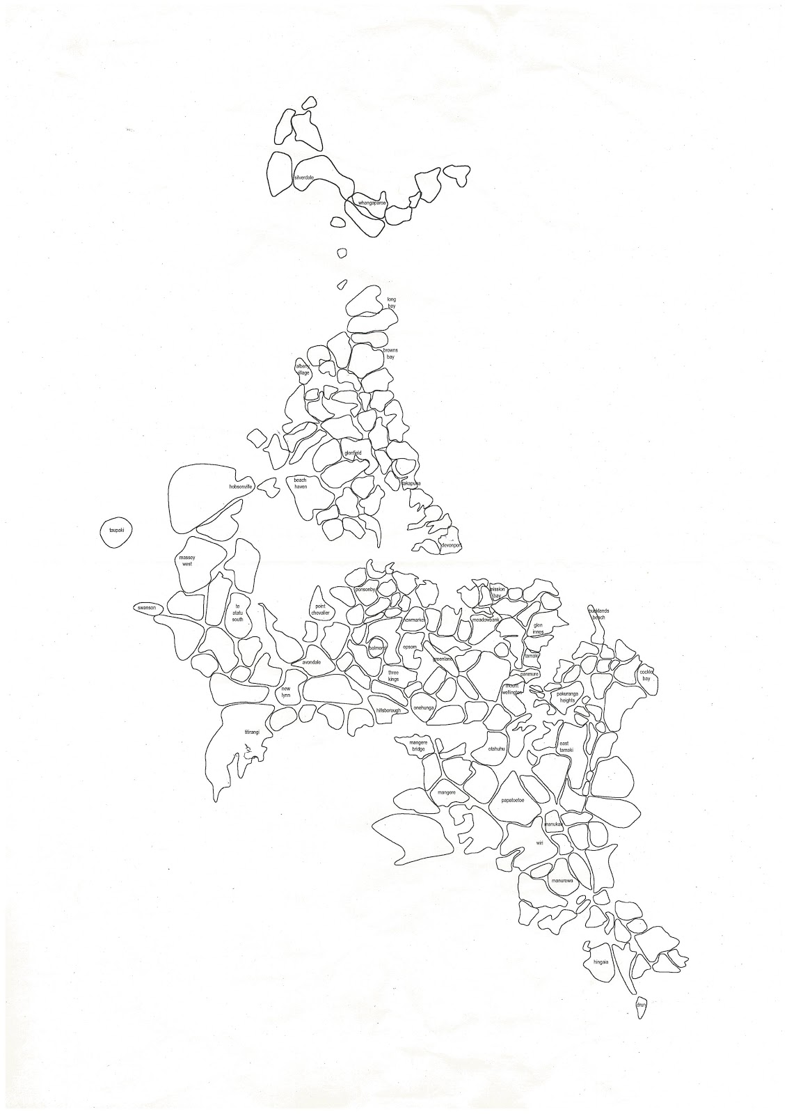
But if we start with the premise that people live in neighbourhoods and generally identify with a particular neighbourhood, then we start with a different picture of the city. The picture is not of large centres and connecting transport corridors, but rather one of a complex mosaic of shapes. (The diagram to the right is from a session that Auckland Council’s urban design team held on the Auckland Plan, of which I was part).
The question becomes as to whether and in what way will future growth change neighbourhoods. Will they get bigger, more densely developed, or will existing neighbourhoods split and divide into new neighbourhoods as growth occurs?
Some new neighbourhoods will be greenfields areas, some will emerge in former industrial areas, others will be in residential areas that infill and redevelop and where neighbourhoods will change and adapt.
How many neighbourhoods does Auckland currently have? Perhaps 200. Why 200? No good reason. A google search of how many neighbourhoods in Auckland gives a list of 220 places. If we drop off 20 to account for rural townships and peri-urban neighbourhoods, then 1.4m divided by 200 equals an average of 7,000 people per neighbourhood. Some are bigger, others smaller. Does another 600,000 people mean another 80 to 90 neighbourhoods?
Of course it all depends upon how you define neighbourhoods. Is it a physical thing - an area with distinct geographic boundaries; is it presence of a range of local services (the corner store or the local supermarket), or is walkability to the local primary school or park? Or is it about the similarity of building types and densities?
I think it is all of the above. But with twists on the theme. For example, there is an argument that runs that neighbourhoods don’t need a commercial centre in their middle to work. Commercial activity can be on the edge of a neighbourhood, perhaps on a main road that sits between two neighbourhoods. Neighbourhoods should have a diversity of building stock, not a uniformity; they need porous edges, not walls. Should we think more strongly about reserves and open spaces and primary schools helping to define the structure of neighbourhoods, than transport and centres?
Below is a diagram from a classic text on neighbourhood planning - Clarence Perry from the 1920s: shopping on the edges, 10% open space, a primary school at the centre. Perry’s concept was of a neighbourhood of 7,000 to 10,000 people. Times have moved on - should it be the retirement village in the middle of the neighbourhood, rather than the school?

As presented by Perry, the neighbourhood is seen as a bit of an island surrounded by big roads. Too insular a view? Perhaps. But I dont think that makes the concept invalid.
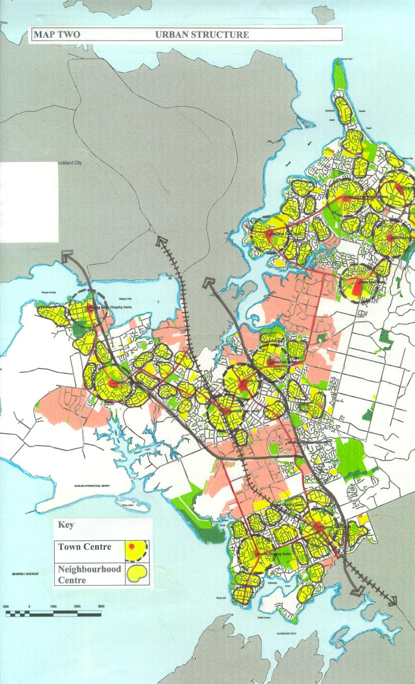
The Auckland Plan and the Unitary Plan have tended to promote growth around existing town centres and along transport corridors. But are these really neighbourhoods?
The Auckland Plan and the Unitary Plan have tended to promote growth around existing town centres and along transport corridors. But are these really neighbourhoods?
Further population growth has the potential to strengthen existing neighbourhoods, but also to see a more complex neighbourhood structure develop over time. The latter prospect is not one that gets much attention in planning, but I think is the hidden benefit of urban intensification. Perhaps increased density should be located not in areas where it reinforces current transport routes and commercial services, but where new growth can help expand the range of variety of neighbourhoods in our suburban areas.
Take a look at any suburban area, and the opportunities to develop a more dense network of neighbourhoods is evident. Below are some examples.

Granted, some neighbourhoods may have a constraints - like heritage building stock - that limit further growth. The above examples are of the middle ring, where opportunities are greater.
In planning we tend to concentrate on the big centres - the sub regionals like Albany, Westgate and Manukau. Growth is concentrated around these centres, and the next layer down - the town centres. But should we also look at the neighbourhood level. If we go from 200 to 300 neighbourhoods, each with their own clustering of mixed use activities, terraces and apartments, adding 600,000 people gets broken down into more manageable chunks. Some new neighbourhoods are formed, others augmented and strengthened. Thinking about another 100 local neighbourhoods being formed and 200 being added to also changes our frame of reference when we think of infrastructure.
In planning we tend to concentrate on the big centres - the sub regionals like Albany, Westgate and Manukau. Growth is concentrated around these centres, and the next layer down - the town centres. But should we also look at the neighbourhood level. If we go from 200 to 300 neighbourhoods, each with their own clustering of mixed use activities, terraces and apartments, adding 600,000 people gets broken down into more manageable chunks. Some new neighbourhoods are formed, others augmented and strengthened. Thinking about another 100 local neighbourhoods being formed and 200 being added to also changes our frame of reference when we think of infrastructure.